Doncaster Ramblers - Triangular walk around Conisbrough
This article contains affiliate links. We may earn a small commission on items purchased through this article, but that does not affect our editorial judgement.
and live on Freeview channel 276
After all it has rolling hills, open vistas, the paths are reasonable and there is a castle.
Today’s triangular walk takes in the southern reaches of Conisbrough Park climbing to 350ft, and is five miles in total.

Advertisement
Hide AdAdvertisement
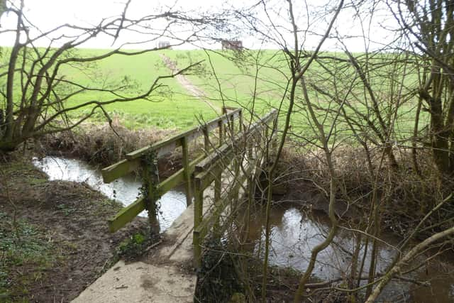
Hide AdStarting at the junction of Sheffield Road and Kearsley Lane head down the lane for 190m then cross a foot bridge on the right.
Begin the slow climb up the hill heading for bushed in the distance eventually finding a gap, pass through and continue along a field edge with hedge on the right.
Keep an eye out for another gap and foot bridge beyond on the right.
Cross the bridge and continue the climb towards two houses on the horizon.
Advertisement
Hide AdAdvertisement
Hide AdOn the day I walked there was a gale blowing, downhill making it hard going.
Continue in the same direction crossing a stile and onwards through a field over a second stile eventually reaching a T junction of paths turn left and follow this bridleway passing some run down farm buildings to reach a crossing of paths with finger post.
Turn right. The route is now down hill however despite being a bridleway this first stretch is poorly defined (there is an alternative route marked in red) otherwise head towards the hedge ahead.
I made the mistake of going left of the hedge which turned out to be water logged but there is also a path on the right.
Advertisement
Hide AdAdvertisement
Hide AdEventually reaching Firsby Hall Farm, take a zigzag right left through then continue straight for 110m before heading off left uphill towards woods.
Enter the woods taking care to follow the path ahead which curves around clockwise for about half a mile exiting onto the A630 Doncaster Road.
The rural part of the walk in now over. The A630 is a fast moving road so cross with care turn right and head uphill.
After quarter of a mile at the Doncaster sign turn left onto Old Road. Stay on Old Road for 1,000m then turn right onto Daylands Avenue for 300m before turning right again on Lewes Road for 470m to reach the start.
Advertisement
Hide AdAdvertisement
Hide AdDoncaster Ramblers local walks now available online. For details visit https://www.doncasterramblers.org.uk/walks/map-of-walking-routes.html and click on walk name for map or gps icon to download file.
Follow Doncaster Ramblers on Facebook https://www.facebook.com/doncasterramblers/ for route description.
Please take care when walking and follow the Countryside Code. Follow government guidelines, you can walk outdoors once a day as part of your daily exercise – by yourself, with members of your household or support bubble, or with one other person. Only walk locally.
*Conisbrough Castle is a medieval fortification . The castle was initially built in the 11th century by William de Warenne, the Earl of Surrey, after the Norman conquest of England in 1066.
In these confusing and worrying times, local journalism is more vital than ever. Thanks to everyone who helps us ask the questions that matter by taking out a subscription or buying a paper. We stand together. Liam Hoden, editor.
Comment Guidelines
National World encourages reader discussion on our stories. User feedback, insights and back-and-forth exchanges add a rich layer of context to reporting. Please review our Community Guidelines before commenting.