Shock flood map that shows Doncaster could be a seaside resort in just 29 years
and live on Freeview channel 276
Large parts of the town could be completely submerged by water in just 29 years, new findings have predicted.
A map, published by Climate Central, shows that the majority of the borough – including Thorne, Bentley, Armthorpe and Cantley - will be underwater by the year 2050.
Advertisement
Hide AdAdvertisement
Hide AdThe map shows floodwater from the North Sea and the River Humber engulfing huge areas of Yorkshire and Lincolnshire – with Doncaster right on the edge of the surging waters.
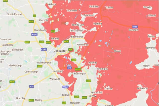

The report is based on global-scale datasets for elevation, tides, and coastal flood likelihoods
In 2019, the report found the UK to be among the top 20 countries most likely to be impacted by subsequent surging sea levels if global temperatures continued to rise as predicted.
That was the conclusion of analysis using machine learning, a form of artificial intelligence, of an 'improved' global elevation dataset.
Advertisement
Hide AdAdvertisement
Hide AdAt the time, Dr Scott Kulp and Dr Benjamin Strauss, senior computational scientist and chief scientist respectively at US-based climate change research group Climate Central, were published in a peer-reviewed paper in the scientific journal 'Nature Communications'.
They said in the report: "As humanity pollutes the atmosphere with greenhouse gases, the planet warms.
"And as it does so, ice sheets and glaciers melt and warming sea water expands, increasing the volume of the world's oceans.
"The consequences range from near-term increases in coastal flooding that can damage infrastructure and crops to the permanent displacement of coastal communities."
Advertisement
Hide AdAdvertisement
Hide AdThey said current projections of sea level increases by the end of the century range from 2ft to 7ft, but could change depending on how much more pollution is dumped into the atmosphere and how quickly the world's glaciers destablilise.
But understanding the effect of that rise in sea levels is incomplete without knowing the relative elevation of land levels.
The authors said much of this data was either unavailable or too expensive to be publicly accessible, so they developed their own computer model to collect the data themselves.
You can view the map HERE