Funding will be used to carry out further flood risk study on Bentley estate in Doncaster
and live on Freeview channel 276
Documents show the Environment Agency has handed DMBC the money to improve the understanding of flood risk in the Frank Road area of the Bentley Flood Corridor.
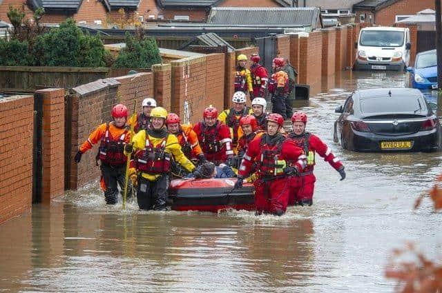
A watercourse next to Frank Road has been the source of flooding in various incidents over the last 100 years affecting a number of streets in the area – most notably in 2007 and 2019 when the River Don burst its banks and caused widespread flooding.
Advertisement
Hide AdAdvertisement
Hide AdIn 2019, devastating floods cost the council over £650,000 in recovery and the equivalent of 2,200 Olympic-sized swimming pools were drained away from one borough village alone every hour for 18 days.

The Environment Agency’s historic flood extent dataset holds several flood records for Bentley.
To the Bentley south area – which consists of Frank Road, Conyers Road, Cromwell Road, Yarborough Terrace, Hunt Lane – there are four records.
Flooding in this area was recorded in May 1932, March 1947, June 2007 and November 2019.
Advertisement
Hide AdAdvertisement
Hide AdThe Bentley Flood Corridor extends from Newton Farm at the upstream end, following the route of Swaithe Dike across York Road and Bentley Road then extending alongside the Don through to Thorpe Marsh flood storage reservoir.

Ea Beck joins the Don at Thorpe Marsh flood storage reservoir and can also therefore overtop its containment embankment at the downstream end contributing to The Bentley Flood Corridor.
Richard Campbell, an environment officer at Doncaster Council, said: “Most of Bentley is designated as Flood Zone 3 on the Environment Agency’s Flood Map for planning which is described as land assessed as having a 1 in 100 or greater annual probability of river flooding.
“Following the November 2019 flood event, DMBC produced a Section 19 report, which identified several key areas and several issues within Bentley, which affected the flooding of the area and identified several recommendations to improve the drainage and minimise any future flooding within the area.
“The studies, which are to be carried out for the Bentley area, will look at developing some of the recommendations from the Section 19 report.”