A wet walk steeped in English history
This article contains affiliate links. We may earn a small commission on items purchased through this article, but that does not affect our editorial judgement.


We had a visitor from the Barnsley group with us today, plus Paul and John both seasoned walkers who dip in and out of led walks from time to time. It’s great having them along as a useful font of knowledge.
We began by walking north through the village of Saxton to the junction of the busy B1217, after about 200m a short way down track on the right we saw the the first information plaques setting out the battle lines. Retracing our steps we
Advertisement
Hide AdAdvertisement
Hide Adcontinued north along a sunken path to avoid the road, turning left at the memorial cross and a further two information boards.
By now the rain was teeming down and a hasty change of clothes was called for. It is a credit to those on today’s walk that they still managed to read the plaques, the final one being The Rockingham Arms in Towton, where we stopped for elevenses, thankfully in the dry.
Returning back along Old London Road now into a sunken gully engulfed by a canopy of trees and shrubs, it was very atmospheric.
Emerging on a metalised track leading to a disused quarry our route continued north towards Wingate Hill (with a hidden Trig Point) where we made a sharp left along Chantry Lane, now moving passed fields cultivated with wheat and barley, before turning left again and heading south towards the hamlet of Lead, stopping on route for lunch in a farmyard.
Advertisement
Hide AdAdvertisement
Hide AdA few remembered the spot from last time they did this walk!
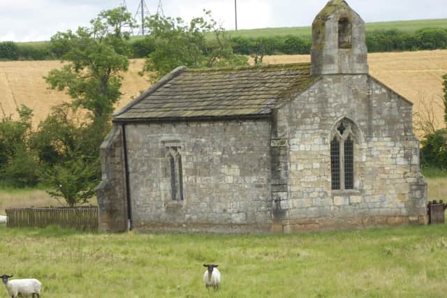
At Lead we made a short detour to visit the tiny St Mary’s
Chapel where Dougy gave a sermon on the demon drink!
The final leg took us east though arable fields back to Saxton and the Greyhound Pub.
Places of interest
St Mary’s Church, Lead, is a redundant Anglican chapel standing in an isolated position in fields some 0.75 miles (1.2 km) to the west of the village of Saxton, North Yorkshire,
England.
Though technically a chapel, it is generally referred to as a church. It is managed by The Churches Conservation Trust, and is recorded in the National Heritage list for England
Advertisement
Hide AdAdvertisement
Hide Adas a designated Grade II* listed building. The chapel stands close to the site of the battle of Towton of 1461, which was part of the Wars of the Roses.
In the 1930s it was saved from neglect by a group of local ramblers, and is known locally as the Ramblers’ Church. (courtesy Wikipedia)
Rules continue to change regarding outdoor exercise and group activity so please visit our website Doncaster Ramblers for the latest, including future activity.
You can also follow us on Facebook Doncaster Ramblers